WORT 89.9FM Madison
Forecast For Wednesday 9 - 25 - 24
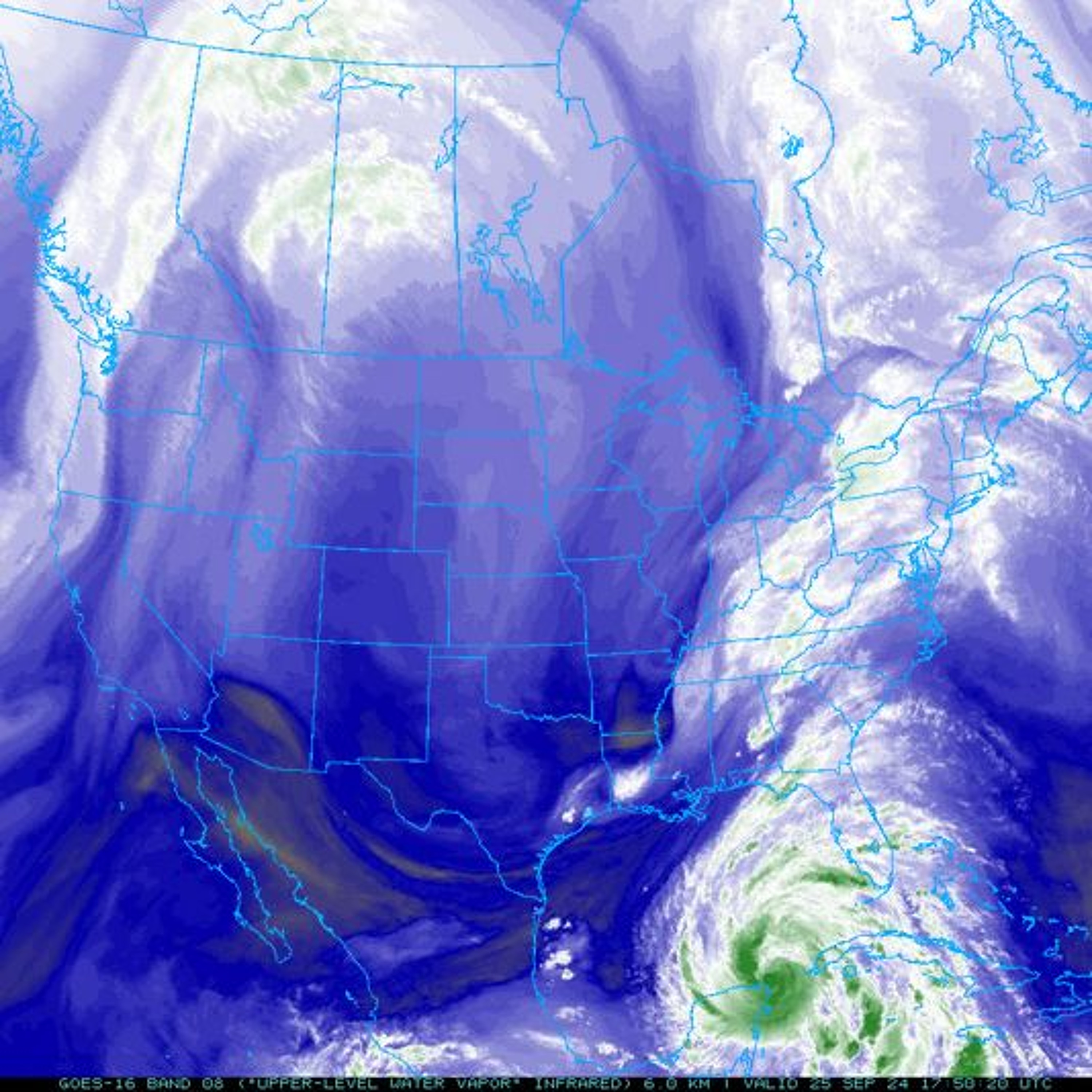
And now it's time for the most comprehensive weather report on the airwaves with WORT weather expert, Rob McClure. Well, last week at this time we were right in the middle of a 10-day streak of temperatures in the upper 80s, which according to the Midwest Regional Employment Center is the longest such streak ever encountered in September in Madison, that goes back to 1939, so fairly remarkable. And as I mentioned on Monday, that warm streak ended on Sunday with the fifth highest single day rainfall ever recorded at Madison, 3.97 inches on Sunday, that period of record for that goes all the way back to 1869, so that's even more astonishing. But it seems we got all of the crazy weather out of the way for the months at this point, I guess, because we've got a compensating period coming up of quite dull and unexceptional weather, a bit warmer than normal, certainly not up in the upper 80s again, though. And a bit breezy as we get out into the weekend, but so far precipitation is not looking to be a problem. It appears we are going to avoid the rains from the remnants of Hurricane Holine, which will be down to our south. We're not going to avoid those rains by much, but it does appear that Hurricane Holine is evidently gonna hold far enough to our south over the weekend to keep precipitation down in Illinois. And of course, Hurricane Holine is basically all the weather there is currently and for the next couple of days. I have added a graphic to the WRRT weather webpage this evening of visible infrared view of the storm down over the southern US and northern Gulf of Mexico, so you can watch the storm's development and then later diminishment over the coming few days is that first strengthens and makes landfall somewhere probably in northwestern Florida and eventually works its way further northward and westward than that up towards us. The storm's intensification is proceeding a pace, but it is really expected to take off as the circulation starts to cross the Gulf of Mexico tonight and tomorrow, passing over 85 to 87 degrees surface waters as it does so. The going estimate for the storm at landfall tomorrow evening is to be at low end category four, but additional intensification beyond that is certainly possible. I have a look at that storm. You can look at it both on that visual image that I mentioned, and if you want to see what's going on over the rest of the continent this evening as well, you might look at it on the water vapor image of the contiguous US that's linked right below that view of Holine up at the top of the WRRT weather webpage. And there you'll see the other upper tropospheric components that will be affecting the weather that we see over the coming few days. One is the upper low that you can see spinning as it drops southward down the eastern plains over these last couple of days on the image. Through the eastern Dakotas, then down into the lower Missouri River Valley, currently down to about Arkansas. That's the circulation that's going to grab on to Holine once the storm comes ashore to its east and whirl its remnants back counterclockwise around it, sending it up towards about southern Illinois by Friday evening and kind of holding onto it there while the two circulations absorb each other's energies. Then the other player in our weather over this coming weekend, the one hopefully that's going to hold our precipitation or hold the precipitation from Holine south and out of our area is the right, we're turning upper high that's wheeling slowly eastward across the northern tier of states in the southern part of Canada between it and the upper levels and the surface high pressure cell associated with it, which is currently over the central and northern plains. We should end up remaining in dry, subcident air through the weekend, although high and possibly middle level clouds spinning off of Holine down to our south may cloud up skies from time to time, especially in areas south of Madison. And we will also see surface winds flowing into Holine's remnant circulation from the northeast through here and those may get a bit brisk as we get on towards Friday and Saturday, especially, otherwise though, a pretty nice five days coming up here, just briefly to the forecast then tonight, the remaining cumulus out there in the sky should die with the sundown and clear skies from there forward, which allow temperatures to drop to the lower mid 50s by dawn with the north, especially winds coming down in near a calm. Tomorrow, clear skies should help get the thermometer to the mid 70s anyway, possibly at a degree or two warmer than that, though there won't be much help from the winds, which will be remaining fairly light, northerly at three to five miles per hour. Temperatures will again drop to the low to mid 50s in the overnight with near calm winds and Friday, high clouds off of post-tropical Holine by that point will be starting to waft northward and northwestward across areas skies, especially south and southeast of Madison. Areas further north and northwest may stay clear entirely or just see a few strands of cirrus passing from east to west as you get up toward north of Madison up towards Sauk County. Temperatures will reach the mid-upper 70s again on Friday on increasing northerly winds, which will come up to eight to 15 miles per hour by the end of the day. We'll stay a bit breezy through the overnight with passing high clouds as well, and that may hold temperatures up in the mid 50s. And Saturday, we'll see high clouds slowly receding back southward so that even more southern areas should start to clear a bit more. Temperatures will reach the upper 70s on northerly winds, still up at eight to 12 miles per hour during the day. And Sunday also looks great, can up in the same temperature range, but with a bit less wind and mostly clear skies. It does appear, we'll finally get a cool down as we get out into the mid part of next week. So it doesn't look like that cooling off will last for any extended period. At the station down here on Bedford Street, currently the temperature is 79, 69 degrees. The dew point is 53, winds are the northwest at five miles per hour, just a cumulus or two left up at about 6,000 feet in an otherwise clear sky and the barometers at 29.9 inches of mercury and the holding study over the past few hours. (upbeat music)
Screen Grab from Colllege of DuPage https://weather.cod.edu/satrad/?parms=global-northamerica-08-96-1-100-6&checked=map&colorbar=undefined